There is a fellow named Billy Beck who I would like to talk about today. Despite his name, he is not a baseball player, but he is about ready to be called up to the majors. He has been studying stream hydrology and erosion at Iowa State University and just finished his Ph.D. I heard him speak recently and thought his material would make a good essay, and with his permission, I wrote this. Most of the images are from him.
Billy has been studying the Walnut Creek Watershed near Prairie City. The watershed (20 square miles) drains much of the Neal Smith National Wildlife Refuge and contains a lot of restored prairie and on-farm conservation practices such as STRIPS. A little over half the watershed is cropped to corn and soybeans. The stream is typical of many in southern and western Iowa in that its hydrology is highly disturbed. What do we mean by that? Well, it has been channelized (Fig. 1).
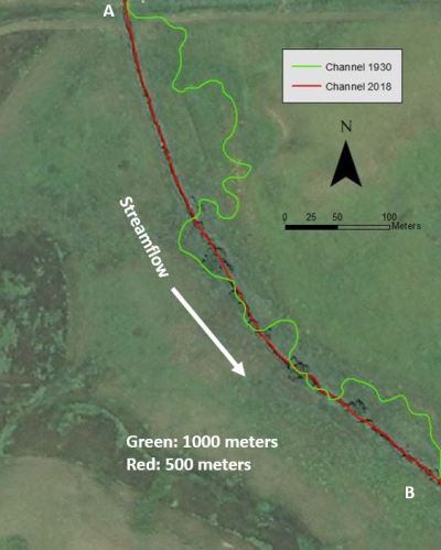
In the 1930s the stream was straightened to make its course more easily workable for farm equipment and crop production. For streams that were also levied during this process, this also simplified construction of dikes and shortened their overall length. If you look at the stretch of 1930 Walnut Creek in Fig. 1, it was about 1000 meters long. Straightening shortened that length to about 500 meters. Straightening did nothing to change the drop in elevation from point A to point B, it’s still the same. Let’s say 10 meters just to make it simple. Before settlement, the slope therefore was a drop of 1 meter for every 100 meters of stream length. After straightening, there is 1 meter drop for every 50 meters of stream length. Gravity being what it is, the water is going to go faster.
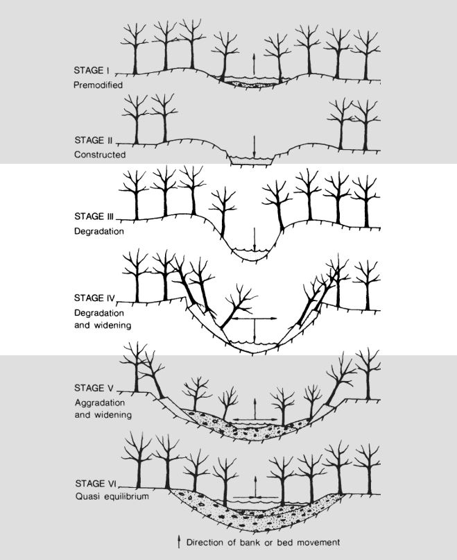
Faster water has more energy and wants to erode stuff. After straightening, much of that energy is going to be directed vertically (downward) rather than laterally. Thus the stream erodes in that direction–down. The stages of progression that result in the formation of a canyon-like stream course are shown in Fig. 2. Prior to settlement, we had shallow meandering streams shaded by trees and other vegetation (top panel I). During straightening we created a trapezoidal stream bed shape (panel II) with steam shovels and dynamite. The stream cuts down (panel III) and the banks begin to slough off into the stream (panel IV). Stage III and IV are where we are with many if not most of our streams, except perhaps in northeast Iowa where the geology is different. Stages V and VI are projections of future stream beds as the process continues.
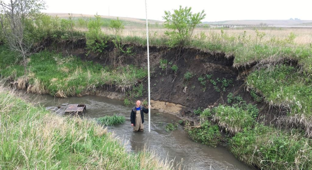
Sloughing of the stream bank into Walnut Creek can be seen in the photo shown in Fig. 3. Almost all that black dirt you see in the photo was deposited there by erosion since Europeans arrived. Because it is loosely consolidated due to recent movement, it is highly vulnerable to further erosion. Take a good look at those sloughing banks, and then look at the photo in Fig. 4 and imagine where those sloughed banks will be when the water goes down (answer: Lake Red Rock). Obviously we hate to lose that soil, but also there is a lot of phosphorus in that material to promote algae blooms in Lake Red Rock and points downstream to the Gulf of Mexico.
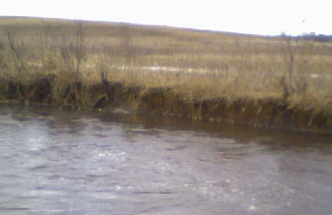
Believe it or not, when mature crops are not in the field, Walnut Creek can cycle from the Fig. 3 condition to the Fig. 4 condition and back to Fig. 3 in a mere 12 hours. Because the stream has cut downward so far, the water rarely spills out into the floodplain where nutrients could otherwise be deposited and stream energy dissipated. As a result, the once shallow, meandering stream that had a frequently romantic relationship with its floodplain is now limited to conjugal visits. And what was once a home to dozens of native fish, reptile, amphibian, and bird species is now effectively a pipe channeling water from an engineered landscape to an engineered reservoir to the engineered Mississippi River where it can travel to the Gulf of Mexico and feed some algae which will eventually die and kill some shrimp in the process. This has been the fate of hundreds of streams throughout Iowa. I’m sure you’ve all seen these canyons driving around the state—they’re not supposed to be there.
“As a result, the once shallow, meandering stream that had a frequently romantic relationship with its floodplain is now limited to conjugal visits.”
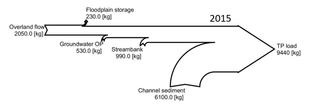
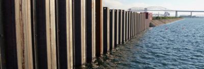
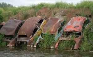
So I’m sure some of you must think at times, why do I insist on being such a cold shower in this space? The reason is that I think if we are going to significantly improve water quality before I die (I’m 58 years old), we need to start having some honest conversations about how we are going to spend money and where are we going to spend it. For an illustration of this, look at Fig. 5, once again created by Billy. Almost 2/3 of the phosphorus leaving the Walnut Creek watershed is from the stream bed and banks. We could completely stop phosphorus loss from the fields and tiles (overland flow and groundwater OP in Fig. 5), and still not come anywhere near the 45% reduction goal stated in the Iowa Nutrient Reduction Strategy. And just how do we address the streambed and bank erosion? Well, we could try armoring the stream banks with rip rap or sheet piling (Fig. 6), but that doesn’t address what we really need—a dissipation of stream energy. Armoring a stream simply transfers that stream energy to spots downstream. (We used to use junk cars for this-Fig. 7. I think you can still see things like this in Iowa). And these methods are expensive and we can’t possibly armor all the streams that need it.
So I would ask the question, should we make precious cost share dollars available to farmers in the Walnut Creek watershed for practices designed to reduce phosphorus loss? I for one think that idea is pretty dubious, at best. If we were following the watershed approach to water quality improvement, we might not. I think Billy’s research has done the state a tremendous service in that it has illustrated the conundrums that exist in developing solutions to these extremely difficult problems.
Thanks Billy, and good luck in the Bigs.
PS: this was the movie version of Billy’s work. If you want to read the book: Beck, W.J., Moore, P.L., Schilling, K.E., Wolter, C.F., Isenhart, T.M., Cole, K.J. and Tomer, M.D., 2019. Changes in lateral floodplain connectivity accompanying stream channel evolution: Implications for sediment and nutrient budgets. Science of The Total Environment, 660, pp.1015-1028.