I admit to looking at the analytics for my various blog posts because hopefully that gives me insights on what people find interesting. The most visited post by far is “Iowa’s Real Population”, and without a doubt it is because of the map. You may recall that I included a map that showed the human waste equivalent of hogs, chickens, turkeys, cattle and people in Iowa’s 56 HUC8 watersheds, and then related that to a place name for each watershed.
I guess people found it intriguing that the fecal equivalent of Chicago, Tokyo, Paris, Rome, Alabama, Oklahoma, and Maine lies upstream of the Des Moines municipal water supply. Go figure. (Des Moines water is eminently safe because of the miracles of modern engineering and the diligent efforts of 200 people at Des Moines Water Works; I know, because I worked there).
Anyway, using the water quality sensor data from IIHR’s Water Quality Information System, I recently aggregated this past year’s stream nitrate-nitrogen (NO3-N) data for Iowa. I am presenting that data here. Please be aware of the notes associated with the data table. There are also some bulleted items at the bottom of this post that concern the table.

You will see from the data table that the load (total mass or weight of a pollutant) delivered from some of these watersheds is in the millions of kilograms. The average person, while recognizing that those numbers are big, often-times asks, what does it mean? Or, how do I put it into some context? I tried to do that in a post from a long time ago. But that map in Iowa’s Real Population hit home.
So what I did here today was take some of those loads in the table at the end and put them into a human context. About 90-95% of the stream nitrate load in Iowa comes from non-point sources, mostly row crop and animal agriculture. But, human beings do excrete some nitrogen and this is eventually released to the environment. When we look at how much nitrogen is discharged from a wastewater treatment facility on a per person basis, it’s about 5 pounds per person per year. I’m going to use Minnesota data (5.1 lbs per person per year) for this analysis just because this source was easy to access.
Taking the load values in the data table from selected sites, converting kilograms to pounds, and then dividing that by 5.1, I get the human equivalent nitrate load and relate that to a place name, in this case states or U.S. territories.
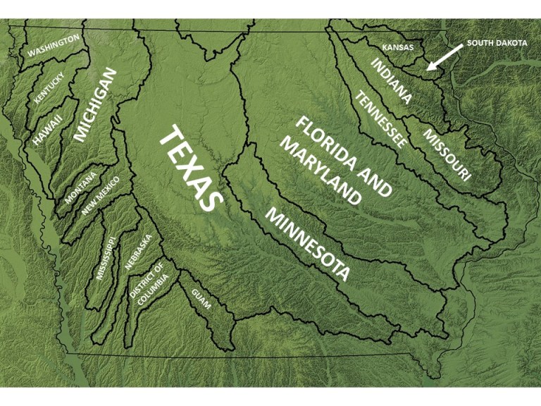
In 2018, the Des Moines River and the combined Cedar-Iowa Rivers both discharged the NO3-N equivalent of about 28 million people (i.e. 56 million in total), with the Des Moines River only about 175,000 pounds larger than the Cedar-Iowa. To the reader, 175,000 pounds may seem like a lot, but that is only the load that would be discharged from the outlet of either watershed in 9 hours, on average. I know, it’s a head slapper.

The total Iowa statewide NO3-N load in the 2018 water year was 626 million pounds, which in treated sanitary sewer discharge would be the equivalent of 123 million people, very similar to the population of Japan. Iowa’s largest NO3-N loading year ever was 2016, when over a billion pounds (1.25 billion) of nitrogen left the state in its rivers, equivalent to 245 million people (Indonesia, the world’s 4th-most populous country). The average statewide NO3-N load since 1999 has been 580 million pounds per year. Another interesting nugget: the total amount of nitrogen leaving Iowa in its rivers in 2018 would fill about 4800 railroad tanker cars, about 13 per day on average.
Here are some more things to keep in mind when reviewing the data table.
- Data is for what we call the Water Year, which in this case runs from 10/1/17 to 9/30/18.
- There are 73 sites in total; 64 of these are managed by IIHR and the others by USGS.
- Sensors at several of the IIHR-managed sites are actually owned by other parties, most notably the Agricultural Research Service (ARS).
- On average, there are nitrate concentration (ppm) data for 231 of the 365 calendar days. Most often the days with missing data are in the winter. I use Iowa DNR ambient monitoring data to fill in missing days where possible, and then use a simple mathematical method called Linear Interpolation to estimate nitrate concentrations on those missing days.
- I use USGS discharge (flow) data to NO3-N loads, which is the total mass (weight) of a pollutant transported by a river past a certain point in a defined period of time. The point in this case is the sensor site.
- Discharge data are not available for all sites. In these cases, I estimate discharge using data from a nearby site and the areas draining to the sensor sites.
- I calculate discharge as water yield, which normalizes the total water flow to the watershed area. In that way we can compare apples to apples when comparing watersheds.
- I also report NO3-N yield, which is the load normalized to the watershed area. Those I report as pounds per acre, both in the total watershed and in the combined area cropped to corn and soybeans.
- One of our major basins is the Cedar-Iowa River watershed monitored at its outlet by USGS at Wapello, Iowa. We have some suspicions that water from the Iowa and the Cedar are incompletely mixed before it passes by the Wapello sensor. For that reason, I am considering the load for that basin to be the Cedar River load at Conesville plus the Iowa River load at Iowa City plus the English River load at Kalona.
- All the data is shown in the table at the end of this post. I organized by major watershed basin whenever possible.